Land Subsidence: UniPD and CNR maps out the global threat
18.02.2021
A study conducted by the University of Padua and the CNR Research Institute for Geo-Hydrological Protection (CNR-IRPI) and the CNR Institute of Geosciences and Earth Resources (CNR-IGG), is the first to highlight that the lowering of the earth's surface is due to the exploitation of subsoil that can cause significant environmental and socio-economic damage. The work, published in the journal Science, was carried out as part of the UNESCO Land Subsidence International Initiative (LaSII).
Subsidence is a lowering of the Earth's land surface due to the removal of solids or fluids from the subsoil. Subsidence due to groundwater depletion develops slowly and gradually, usually affecting compressible soils. Studies on the physical process began in the last century, but until now, researchers had only focused on the analysis and resolution of the problem on a local scale.
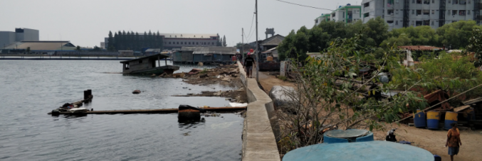
"Although subsidence is a slow and gradual process, it can permanently reduce the water storage capacity of aquifer systems, damaging buildings and infrastructure, as well as increasing the risk of flooding in certain areas and along coastal plains. Subsidence greater than 25 cm/year is evident in several global regions including Iran, Mexico, and Indonesia. In fact, in Indonesia, coastal subsidence in Jakarta is so severe that the government is planning to move the capital to the island of Borneo (pictured above, the Pluit waterfront district in Jakarta, Indonesia). The subsidence also affects many coastal areas in Italy, especially in Emilia-Romagna, Veneto, Puglia, Tuscany, Campania, and Calabria," says Pietro Teatini of the University of Padua and president of UNESCO-LaSII. “It is necessary that we become more aware as this is a slow and silent process that increasingly impact the lives of people living in different areas around the world, especially in the poorest urban centres of developing countries."
The results of this study are quite relevant, in a statement from Mauro Rossi of CNR-IRPI and expert in hydrogeological risk modelling, "Potential subsidence areas will impact the lives of 1.2 billion people, reaching 21% of all major cities, and exposing 86% of the global population who live in Asia. The research also estimates that the current economic exposure to potential subsidence amounted to 8.17 trillion dollars, totalling 12% of the world's GDP (Gross Domestic Product). A predictive simulation for 2040, which also takes into account the effects of global change in terms of rising sea levels, shows that about 635 million people will live in areas where subsidence will be living in flood-prone areas. To raise awareness and inform public authorities, we have taken a statistical method to globally map out subsidence related to geological, geomorphological, land use, and climate variables. Such a methodology can help identify newly affected areas and guide mitigation actions."
Subsidence is particularly impact coastal areas. As sea levels rise, due to climate change, subsidence exacerbates the lowering of the land surface. Luigi Tosi of CNR-IGG concludes by saying, "Almost 200 km of the northern Adriatic coast have altitude below, or just above, the average sea level. In these areas, even a few centimetres of subsidence can increase the probability of flooding. Territorial planners, urban planners, and surface water body management authorities could use the information provided by this study to prevent or mitigate the impact of subsidence, especially in the context of global change."