Greenland: A 200-meter-high mega-tsunami shook seismometers around the world for 9 days. International research
16.09.2024
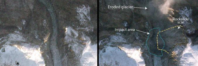
A massive landslide caused by the collapse of a mountaintop in the remote Dickson Fjord in northeastern Greenland generated a 200-meter-high mega-tsunami that continued for 9 days, sending a seismic signal across the world that had never been seen before.
The study, A rockslide-generated tsunami in a Greenland fjord rang the Earth for 9 days recently published in Science, is thanks to the collaborative work of 68 scientists from 40 institutions across 15 countries. For those in Italy, the universities of Padua and Catania, as well as the National Institute of Geophysics and Volcanology (INGV) took part in the research.
Prof Kristian Svennevig of the Geological Survey of Denmark and Greenland (GEUS) and lead author of the study explains, “When we started this scientific adventure, we were all quite puzzled and none of us had the slightest idea what had caused this peculiar seismic signal. We knew that it was somehow associated with the landslide, but this was the first landslide and tsunami due to ice melt observed in eastern Greenland. Our work shows that climate change strongly impacts our world today.”
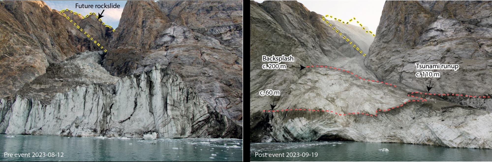
Photos of the mountain peak and the glacier before and after the rockslide caused a globally perceptible signal. (photos: Søren Rysgaard (left), Danish Army (right) / collage: Elias Kobel, kit)
The multidisciplinary team analyzed seismic and infrasound data, field measurements, data from the local network of oceanographic sensors, live and satellite images, and numerical simulations of tsunami waves. The collected data managed to reconstruct the extraordinary cascade of events triggered in September of last year.
“Multidisciplinary data analysis confirmed that the mega-tsunami resulting from the landslide was one of the highest ever recorded in recent history, reaching 200 meters of wave inside the fjord. About 70 kilometers away, tsunami waves reached 4 meters in height, damaging a research base on the island of Ella Ø”, adds Piero Poli, a researcher at the University of Padua and co-author of the study. “The movement of such a mass of water was able to generate vibrations through the Earth, with seismic waves that, radiating from the Arctic to the Antarctic, generated an anomalous global seismic signal. This event underlines the importance of creating special systems for monitoring seismic data at a global scale, which allow the rapid identification and characterization of new and increasingly frequent signals associated with surface processes, such as landslides and rapid movements of ice or fluids, associated with climate change.”
The team’s simulations showed that the water in the fjord swayed back and forth every 90 seconds, the same period of oscillation as the seismic waves. This correspondence indicates that the force of the moving water mass was able to generate seismic energy that propagated through the Earth’s crust.
Before losing strength, the event was energetic enough to generate a global signal that resonated for 9 days. Never had a seismic wave of such a long duration traveled globally and contained a single frequency of vibration.